The Ansbacher Map Collection has a sub-collection of the Le Moyne-De Bry engravings located in the Jordan & Shirley Ansbacher Gallery in the Special Collections department.
In 1562 French naval officer, navigator and colonizer Jean Ribault discovered the St. Johns River, and claimed the surrounding land for France. This claim brought about a struggle between imperial Spain and France for control and dominance of the New World. Two years later Rene de Laudonniere established a settlement at Fort Caroline, creating a foothold in Florida for France, and setting a course for a confrontation with the Spanish.
Artist Jacques Le Moyne served as the official mapmaker on Laudonniere’s expedition. He made drawings that portrayed the life and culture of Florida natives, including the Timucua, at the new settlement. In 1565 Pedro de Menendez, intent on destroying the French, established St. Augustine, and conquered Fort Caroline for the Spanish. Le Moyne was one of the few French to escape.
His drawings of native life in the New World were later made into engravings by Flemish engraver Theodor De Bry who then published the collection in 1591.
The Le Moyne/De Bry Collection comprises 43 engravings, which are on public display in the Jordan and Shirley Ansbacher Gallery. They are part of the Lewis Ansbacher Map Collection at the Jacksonville Public Library and included on Map Room tours.
You can also view the digitized engravings online.
Book a One-on-One Appointment in Special Collections
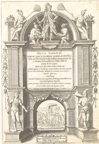
Title Plate. A Brief Narration of Those Things Which Befell the French in the Province of Florida in America...
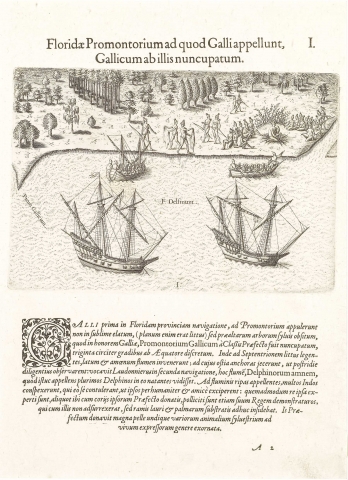
Plate I. The Promontory of Florida, at Which the French Touched; Named by Them the French Promontory
The French on their first voyage to Florida, touched at a headland, not very high, as the coast in that vicinity is level, but heavily wooded with very lofty trees. This their commander named French Cape [Promontorium Gallicum] in honor of France It is about thirty degrees from the equator. Coasting thence to the northward, they discovered a broad and beautiful river, at whose mouth they cast anchor in order to examine it more in detail next day. Laudonnière, in his second voyage, called this stream the River of Dolphins, because, when he touched there, a great many dolphins were seen in it. On landing on the shore of this river, our men saw many Indians, who came on purpose to give them a most kind and friendly reception, as their actions proved; for some of them gave their own skin-garments to the commander, and promised to point out to him their chief, who did not rise up, but remained sitting on boughs of laurel and palm which had been spread for him. He gave our commander a large skin, decorated all over with pictures of various kinds of wild animals drawn after the life.
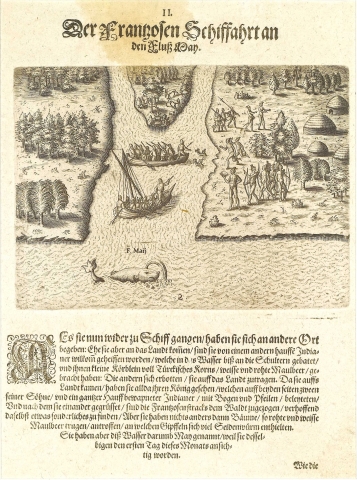
Plate II. The French Sail to the River of May
Re-embarking, they sailed to another place; and before landing again, were received with salutations by another crowd of Indians, some of whom waded into the water up to their shoulders, offering the visitors little baskets full of maize and of white and red mulberries, while others offered to help them in going to shore. Having landed, they saw the chief, who was accompanied by two sons, and a company of Indians armed with bows and quivers full of arrows. After an exchange of salutations, our men went on into the woods, in hopes to discover many wonderful things. They found nothing, however, except trees bearing white and red mulberries, on the boughs of which were numerous silk worms. They named this river the River of May, because they sighted it on the first day of that month.
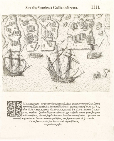
Plate IV. Six Other Rivers Discovered by the French
Sailing hence, about six miles farther on they discovered another river, which was called the Loire; and subsequently five others, named the Charente, Garonne, Gironde, Beautiful [Bellus], and Great, respectively. Having carefully explored all these, and having discovered along these nine rivers, within the space of less than sixty miles, many singular things, but still not being contested, they proceeded still farther north, until they arrived at the River Jordan, which is almost the most beautiful river of the whole of this northern region.
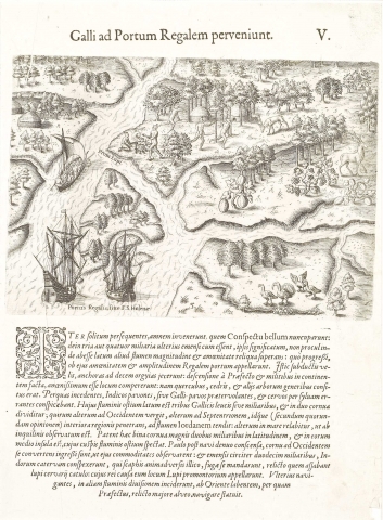
Plate V. The French Reach Port Royal
Resuming their voyage as before, they discovered a river which they called Bellevue [Conspectu bellum, “beautiful view”]; and, after sailing three or four miles farther, they were informed that not far off was another river, surpassing all the rest in size and beauty. When they reached this, they found it so magnificent and great a stream that they named it Port Royal. Here they took in sail, and came to anchor in ten fathoms. The commander, on landing with some soldiers, found the country very beautiful, as it was well wooded with oak, cedar, and other trees. As they went on through the woods, they saw Indian peacocks, or turkeys, flying past, and deer going by. The mouth of this river is three French leagues, or miles, wide, and is divided onto two arms, one turning to the west, the other to the north. This latter is thought by some to connect with the Jordan; the other returns to the sea, as residents there have ascertained. These two branches are two full miles wide, and midway between them is an island whose point looks toward the mouth of the river. Shortly after, embarking again, they entered the arm making to the northward, in order to examine its advantages; and, after proceeding about twelve miles, they saw a company of Indians, who, on perceiving the boats, immediately took flight, leaving a lynx’s whelp which they were roasting; from which circumstances the place was called Lynx Point. On going still farther, they came to another branch of the river coming in from the east, up which the commander determined to go, leaving the main channel.
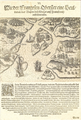
Plate VI. The French Commander Erects a Column with the Arms of the King of France
The commander having, however, returned to his ships, and having remained on the board one night, ordered into one of the boats a landmark carved in the form of a column, and having cut upon it the arms of the King of France, which was directed to be set up in some particularly pleasant spot. Such they found a point about three miles less to the west, where they discovered a small creek, which they entered, and, after following it for a time, found that it came out into the main stream again, this forming a small island. The commander directed the column to be erected on a small open mound in this lace. After this they saw two deer of great size in comparison with any they had seen before, and which they could easily have killed with their arquebuses, had not the commander, admiring their large size, forbidden it. Before returning to the boat, they named this small island Libourne. Embarking again, they explored another island not far from the former; but finding upon it nothing except some very lofty cedars, larger than any they had yet seen in the country, they called it Cedar Island, and then returned to the ships. The small island on which the column was erected is marked F in the plate.
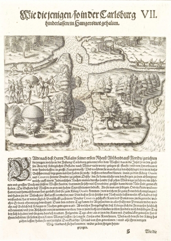
Plate VII. The French Left in Fort Charles Suffer the Scarcity of Provisions
Not long after the departure of Ribault from Florida, the men whom he left in Charlesfort (the work erected by him on an island in a stream entering the greater channel of Port Royal from the north) began to find their provisions fail them. After consulting the best way of meeting the difficulty, they concluded that the wisest plan was to apply to the chief Ouadé and his brother Couëxis. Those who were sent on this business went in Indian canoes by the inland waters, and at a distance of some ten miles discovered a large and beautiful river of fresh water, in which they saw numerous crocodiles, much larger than those of the Nile. The banks of this stream were wooded with lofty cypresses. After a short delay here, they went on to the chief Ouadé; and, being received by him in the most friendly manner, they laid before him the object of their journey, and prayed him not to desert them in such a strait. Upon hearing this, the chief sent messengers to his brother Couëxis after maize and beans. The latter responded promptly; for the next morning very early the messengers came back with the provisions, which the chief ordered on board the canoe. The French, very happy at this liberality of the chief, would have taken leave of him; but this he would not permit, keeping them with him, and entertaining them hospitably for that day. Next morning he showed them his fields of millet, or maize, and intimated that they should not want for food as long as that millet existed. Being now dismissed by the king, they returned by the way they had come.
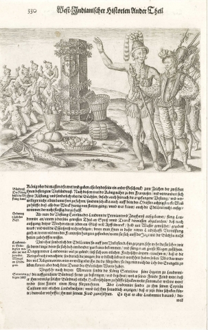
Plate VIII. The Natives of Florida Worship the Column Erected by the Commander of his First Voyage
When the French landed in Florida on their second voyage under Laudonnière, that leader went on shore with five and twenty arquebusiers, after obtaining a safe-conduct from the Indians, who had gathered in crowds to see them. The chief Athore, who lived four or five miles from the seashore, also came; and after an exchange of presents had been made, accompanied by demonstrations of all manner and kind feeling, the chief gave them to understand that he wished to show them something remarkable, and that he desired they would go with him for that purpose. To this consent was given; although, as the chief had with him a great number of his people, caution and circumspection were used. He then conducted them directly to the island where Ribault had set up on a mound a stone column ornamented with the arms of the King of France. On approaching, they found that these Indians were worshipping this stone as an idol; and the chief himself, having saluted it with signs of reverence such as his subjects were in the habit of showing to himself, kissed it. His men followed his example, and we were invited to do the same. Before the monument there lay various offerings of the fruits, and edible or medicinal roots, growing thereabouts; vessels of perfumed oils; a bow and arrows; and it was wreathed around the top to bottom with flowers of all sorts, and boughs of the trees esteemed choicest. After witnessing these ceremonies of these poor savages, our men returned to their companions, and set about choosing a place for erecting a fort. This chief, Athore, is very handsome, prudent, honorable, strong, ad of very great stature, being more than half a foot taller than the tallest of our men; and his bearing was marked by a modest gravity, which had strikingly majestic effect. He had married his mother, and had by her a number of sons and daughters, whom he showed to us, striking his thigh as he did so. After his marriage, his father Saturioua lived with her no longer.
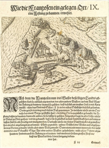
Plate IX. The French Select a Place for Building a Fort
After exploring many of the rivers in that country, it was finally decided that the River of May was the best one for an establishment, because millet [i.e., maize] and breadstuffs were most abundant there, besides the gold and silver that had been discovered there on the first voyage. They therefore sailed for that river; and, after ascending it to the neighborhood of a certain mountain, they selected a place more fit for the site of their fort than any previously observed. Nest day, as soon as it was light, after offering prayers to god, and giving thanks for their prosperous coming into the province, they all went briskly to work; and, after a triangular outline had been measured out. They all began- some to dig in the earth, some to make fascines of brushwood, some to put up the wall. Every man was briskly engaged with spade, saw, axe, or some other tool; and so diligent were they that the work went rapidly forward.
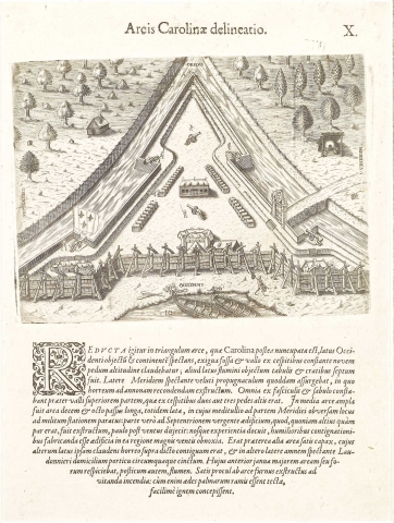
Plate X. Picture of Fort Caroline
Thus was erected a triangular work, afterwards named Fort Caroline. The base of the triangle, looking westward, was defended only by a small ditch, and a wall of sods nine feet high. The side near the river was built up with planks and fascines. On the southern side was a building after the fashion of a citadel, which was for a granary to hold their provisions. The whole was of fascines and earth, except the upper part of the wall for two or three feet, which was of sods. In the middle if the fort was a roomy open space eighteen yards long, and as many wide. Midway on the southern side of this space were the soldiers’ quarters; and on the north side was a building which was higher than it should have been, and was in consequence blown over by the wind a little afterwards. Experience thus taught us that in this country, where the winds are so furious, houses must be built low. There was also another open space, pretty large, one side of which was closed in by the granary above mentioned, while on another side stood the residence of Laudonnière, looking out upon the river, and with a piazza all round it. The principle door of this opened upon the larger open space; and the rear door, upon the river.at a safe distance from the works, an oven was erected; for, as the houses were roofed with palm branches, they would very easily have caught fire.
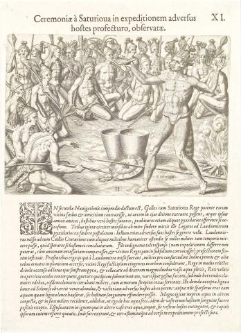
Plate XI. Ceremonies Performed by Saturioua Before Going on an Expedition Against the Enemy
It is mentioned in the account if the second voyage that the French made a treaty of friendship with a powerful chief of the vicinity, named Saturioua, with agreement that they were to erect a fort in his territory, and were to be friends to his friends, and enemies to his enemies;
and, further, that on occasion they should furnish him some arquebusiers. About three months afterwards, he sent messengers to Laudonnière to ask for the arquebusiers according to the treaty, as he was about to make war upon his enemies. Laudonnière, however, sent to him Captain La Caille with some men, to inform him courteously that he could not just then supply any soldiers, for the reason that he hoped to be able to make peace between the parties. But the chief was indignant at this reply, as he could not now put off
his expedition, having got his provisions ready, and summoned the neighboring chiefs to his aid; and he heretofore prepared to set out at once. He assembled his men decorated, after the Indian manner, with feathers and other things, in a level place, the soldiers of Laudonnière being present; and the force sat down in a circle, the chief being in the middle. A fire was then lighted on his left, and two great vessels full of water were set on his right. Then chief, after rolling his eyes as if excited by anger, uttering some sounds deep down in his throat, and making various gestures, all at once raised a horrid yell; and all his soldiers repeated this yell, striking their hips and rattling their weapons. Then the chief, taking a wooden platter of water, turned toward the sun, and worshiped it; praying to it for a victory over the enemy, and that, as he should now scatter the water that he had dipped up in the wooden platter, so might their blood be poured out. Then he flung water with a great cast up into the air; and, as it fell down upon his men, he added, “As I have done with this water, so I pray you may do with the blood of your enemies.” Then he poured the water in the other vase upon the fire, and said, “So may you be able to extinguish your enemies, and bring back their scalps.” Then they all arose, and set off by land up the river, upon their expedition.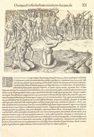
Plate XII. Outina, going at the Head of His Army, Against the Enemy, Consults a Sorcerer on the Event
Laudonnière, having received some of the men of the chief, Holata Utina, or Outina, living about forty miles south from the French fort, and who had been taken in a previous expedition by his enemy Saturioua, sent them back to their chief, upon which a solemn league ws made, and a mutual friendship promised. This treaty was made for the reason that the only road, whether by land or by the rivers, to the Apalatcy Mountains, in which gold, silver, and copper [æs] are found, was through the dominions of this chief; and it was in his friendship, now of scarcely a year’s standing, that the French trusted to obtain free access to these mountains. As this friendship, however, was still in force, he asked Laudonnière for some arquebusiers, as he wished to make war on an enemy; on which twenty-five were sent him, under d’Ottigny, Laudonnière’s lieutenant. The chief received them with great
delight, as he made sure of the victory through their assistance; for the fame of the arquebuses had penetrated throughout all that region, and had struck all with terror. The chief having therefore completed his preperations, the army marched. Their first day’s journey was easy; the second very difficult, being through swamps thickly overgrown with thorns and brambles. Here the Indians were obliged to carry the French on their shoulders, which was the greater relief by reason of the extreme heat. At length they reached the enemy’s territories, when the chief halted his force, and summoning an aged sorcerer, more than a hundred and twenty years old, directed him to report what was the state of affairs with the enemy. The sorcerer accordingly made ready a place in the middle of the army and, seeing the shield which d’Ottigny’s page was carrying, asked to take it. On receiving it, he laid it on the ground, and drew around it a circle, upon which he inscribed various characters and signs. Then he knelt down on the shield and sat on his hells, so that no part of him touched the earth, and began to recite some unknown words in a low tone, and to make various gestures, as if engaged in vehement discourse. This lasted for a quarter of an hour, when he began to assume an appearance so frightful that he was hardly like a human being, for he twisted his limbs so that the bones could be heard to snap out of place, and did many unnatural things. After going through with all this, he came back all at once to his ordinary condition, but in a fragile state, and with an air as if astonished; and then, stepping out of his circle, he saluted the chief, and told him the number of the enemy, and where they were intending to meet him.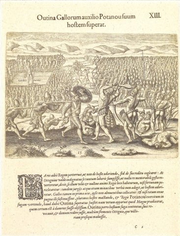
Plate XIII. Thanks to the French, Outina Gains a Victory over his Enemy Potanou
This report so terrified the chief that he began to consider not how to come up with the enemy, but how to get safe back again. But d’Ottigny, greatly vexed at the idea of making such exertions only to return without bringing anything to pass, threatened to consider him a base chief, and of no courage, if he should not risk an action; and, by force of reproaches and some threats too, brought him to order an attack. He, however, put the French in the advance, as they were quite willing to have him do; and indeed, unless they had sustained the whole brunt of the battle, killing very many of the enemy, and putting to flight the army of the chief Potanou, there is no question but Outina would have been routed; for it became evident that the sorcerer had made a true report of the facts, and he must certainly have been possessed by a devil. Outina, however, quite contented with the flight of the enemy, recalled his men, and marched for home, to the great wrath of d’Ottigny, who wished to follow up the victory.
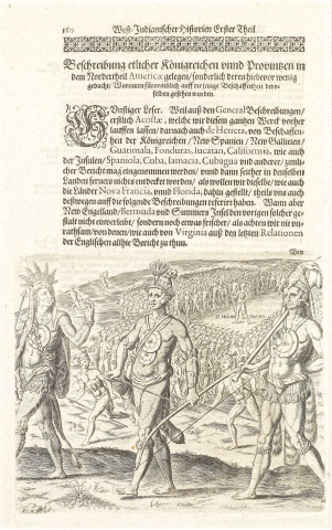
Plate XIV. The Military Discipline Observed by Outina when Leaving for War
When Saturioua went to war, his men preserved no order, but went along one after another, just as it happened. On the contrary, his enemy Holata Outina, whose name, as I now remember, means “king of many kings,” and who was much more powerful than he as regards both wealth and number of his subjects, used to march with regular ranks, like an organized army; himself marching alone in the middle of the whole force, painted red. On the wings, or horns, of his order of march were his young men, the swiftest of whom, also painted red, acted as advance guards and scouts for reconnoitering the enemy. These are able to follow up the traces of the enemy by scent, as dogs do wild beasts; and when they come upon such traces, they immediately return to the army to report. And, as we make use of trumpet and drums in our armies to promulgate orders, so they have heralds, who by cries of certain sorts direct when to halt, or to advance, or to attack, or to perform any other military duty. After sunset they halt, and are never wont to give battle. For encamping, they are arranged in squads of ten each, the bravest men being put in squads by themselves. When the chief has chosen the place of encampment for the night, in open fields or woods, and after he has eaten, and is established by himself, the quartermasters place ten of these squads of the bravest men in a circle around him. About ten paces outside of this circle is placed another line of twenty squads; at twenty yards farther, another of forty squads; and so on, increasing the number and distance of these lines, according to the size of the army.
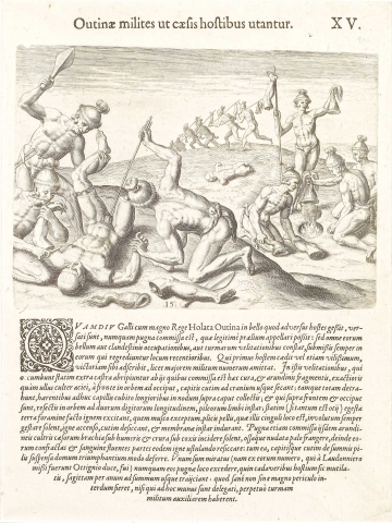
Plate XV. How Outina's Soldiers Treated their Slain Enemies
At no time while the French were acting along with the great chief Holata Outina in his wars against his enemies, was there any combat which could be called a regular battle; but all their military operations consisted either in secret incursions, or in skirmishes as light troops, fresh men being constantly sent out in place of any who retired. Whichever side first slew an enemy, no matter how insignificant the person, claimed the victory, even though losing a greater number of men. In their skirmishes, any who fall are instantly dragged off by persons detailed for the purpose; who, with slips of reeds sharper than any steel blade, cut the skin of the head to the bone, from front to back, all the way round, and pull it off with the hair, more than a foot and a half long, still adhering, done up in a knot on the crown, and with that lower down around the forehead and back cut short into a ring about two fingers wide, like the rim of a hat. Then, if they have time, they dig a hole in the ground and make a fire, kindling it with some which they keep burning in moss, done up in skins, and carry round with them at their belts; and then dry these scalps to a state as hard as parchment. They also are accustomed, after a battle, to cut off with these reed knives the arms of the dead near the shoulders, and their legs near the hips, breaking the bones, when laid bare, with a club, and then to lay these fresh broken, and still running with blood, over the same fires to be dried. Then hanging them, and the scalps also, to the ends of their spears, they carry them off home in triumph. I used to be astonished at one habit of theirs- for I was one of the party whom Laudonniere sent out under M. d’Ottigny which was that they never left the field of battle without shooting an arrow as deep as they could into the arms of each of the corpses of the enemy, after mutilating them as above; an operation which was sometimes sufficiently dangerous, unless those engaged in it had an escort of soldiers.
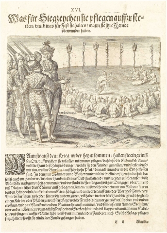
Plate XVI. The Erection of Trophies and the Ceremonies Intended to Celebrate the Defeat of the Enemy
After returning from a military expedition, they assemble in a place set apart for the purpose, to which they bring the legs, arms, and scalps which they have taken from the enemy, and with solemn formalities fix them up on tall poles set in the ground in a row. Then they all, men and women, sit down on the ground in a circle before these mem bers; while the sorcerer, holding a small image in his hand, goes through a form of curs ing the enemy, uttering in a low voice, according to their manner, a thousand imprecations. At the side of the circle opposite to him, there are placed three men kneeling down, one of whom holds in both hands a club, with which he pounds on a flat stone, marking time to every word of the sorcerer. At each side of him, the other two hold in each hand the fruit of a certain plant, something like a gourd or pumpkin, which has been dried, opened at each end, its marrow and seeds taken out, and then mounted on a stick, and charged with small stones or seeds of some kind. These they rattle after the fashion of a bell, accompanying the words of the sorcerer with a sort of song after their manner. They have such a celebration as this every time they take any of the enemy.
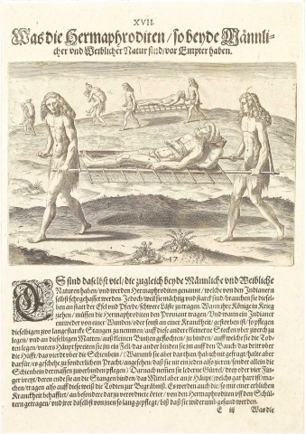
Plate XVII. Functions of the Hermaphrodites
Hermaphrodites, partaking of the nature of each sex, are quite common in these parts, and are considered odious by the Indians themselves, who, however, employ them, as they are strong, instead of beasts of burden. When a chief goes out to war, the hermaphrodites carry the provisions. When any Indian is dead of wounds or disease, two hermaphrodites take a couple of stout poles, fasten crosspieces on them, and attach to these a mat woven of reeds. On this they place the deceased, with a skin under his head, a second bound around his body, a third around one thigh, a fourth around one leg. Why these are so used, I did not ascertain; but I imagine by way of ornament, as in some cases they do not go so far, but put the skin upon one leg only. Then they take thongs of hide, three or four fingers broad, fasten the ends to the ends of the poles, and put the middle over their heads, which are remarkably hard; and in this manner they carry the deceased to the place of burial. Persons having contagious diseases are also carried to places appointed for the purpose on the shoulders of the hermaphrodites, who supply them with food and take care of them, until they get quite well again.
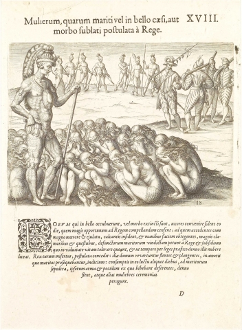
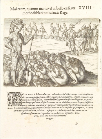
Plate XVIII. Petitions Addressed to the King by the Wives whose Husbands have Died
The wives of such as have fallen in war, or died by disease, are accustomed to et together on some day which they find convenient for approaching the chief. They come before him with great weeping and outcry, sit down on their heels, hide their faces in their hands, and with much clamor and lamentation require of the chief vengeance for their dead husbands, the means of living during their widowhood, and permission to marry again at the end of the time appointed by law. The chief, sympathizing with them, assents; and they go home weeping and lamenting, so as to show the strength their love for the deceased. After some days spent in this mourning, they proceed to graves of their husbands, carrying the weapons and drinking cups of the dead, and there they mourn for them again, and perform other feminine ceremonies.
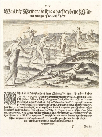
Plate XIX. Ceremonies of thae Women in Mourning for their Husbands
After coming to the graves of their husbands, they cut off their hair below the ears, and scatter it upon the graves; and then cast upon them the weapons and drinking shells of the deceased, as memorials of brave men. This done, they return home, but are not allowed to marry again until their hair has grown long enough to cover their shoulders. They let their nails grow long both on fingers and toes, cutting the former away, however, at the sides, so as to leave them very sharp, the men especially; and, when they take one of the enemy, they sink their nails deep in his forehead, and tear down the skin, so as to wound and blind him.
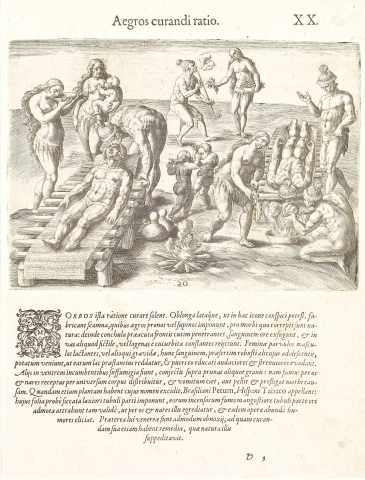
Plate XX. How the Indians Cure their Sick
Their way of curing diseases is as follows: They put up a bench or platform of sufficient length and breadth for the patient, as seen in the plate, and lay the sick person upon it with his face up or down, according to the nature of his complaint; and, cutting into the skin of the forehead with a sharp shell, they suck out blood with their mouths, and spit it into an earthen vessel or a gourd bottle. Women who are suckling boys, or who are with child, come and drink this blood, particularly if it is that of a strong young man, as it is expected to make their milk better, and to render the children who have the benefit of it bolder and more energetic. For those who are laid on their faces, they prepare fumigations by throwing certain seeds on hot coals, the smoke being made to pass through the nose and mouth into all parts of the body, and thus to act as a vomit, or to overcome and expel the cause of the disease. They have a certain plant whose name has escaped me, which the Brazilians call petum, and the Spaniards tapaco. The leaves of this, carefully dried, they place in the wider part of a pipe; and setting them on fire, and putting the other end in their mouths, they inhale the smoke so strongly, that it comes out at their mouths and noses, and operates powerfully to expel the humors. In particular, they are extremely subject to the venereal disease, for curing which they have remedies of their own, supplied by nature.
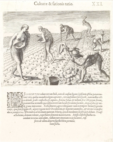
Plate XXI. Cultivation and Sowing
The Indians cultivate the earth diligently; and the men know how to make a kind of hoe from fish bones, which they fit to a wooden handle, and with to prepare the land well enough, as the soil is light. When the ground is sufficiently broken up and leveled, the women come with beans and millet, or maize. Some go first with a stick, and make holes in which the others place the beans, or grains of maize. After planting they leave the fields alone, as the winter in that country, situated between the west and the north, is pretty cold for about three months, being from the 24th of December to the 15th of March; and during that time, as they go naked, they shelter themselves in the woods. When the winter is over, they return to their homes to wait for their crops to ripen. After gathering in their harvest, they store the whole of it for the year’s use, not employing any part of it in trade, unless, perhaps, some barter is made for some little household article.
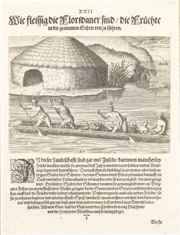
Plate XXII. The Industry of the Floridians in Storing the Products of the Harvest
There are in that region a great many islands, producing abundance of various kinds of fruits, which they gather twice a year, and carry home in canoes, and store up in roomy low granaries built of stones and earth, and roofed thickly with palm branches and a kind of soft earth fit for the purpose. These granaries are usually erected near some mountain, or on the bank of some river, so as to be out of the sun’s rays, in order that the contents may keep better. Here they also store up any other provisions which they may wish to preserve, and the remainder of their stores; and they go and get them as need may require, without any apprehensions of being defrauded. Indeed, it is to be wished that, among the Christians, avarice prevailed no more than among them, and tormented no more the minds of men.
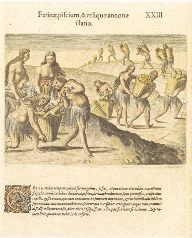
Plate XXIII. Bringing in Game, Fish and other Provisions
At a set time every year they gather in all sorts of wild animals, fish, and even crocodiles; these are then put in baskets, and loaded upon a sufficient number of the curly haired hermaphrodites above mentioned, who carry them on their shoulders to the store house. This supply, however, they do not resort to unless in case of the last necessity. In such event, in order to preclude any dissension, full notice is given to all interested; for they live in the utmost harmony among themselves. The chief, however, is at liberty to take whatever of this supply he may choose.
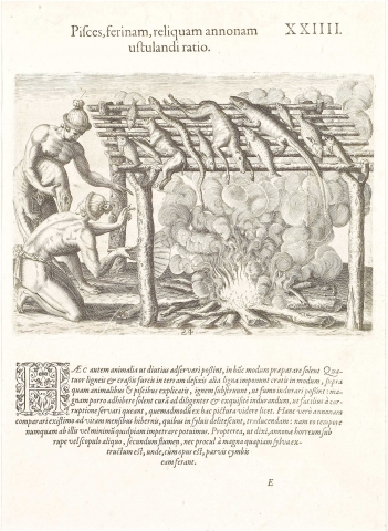
Plate XXIV. Mode of Drying Fish, Game and other Provisions
In order to keep these animals longer, they are in the habit of preparing them as follows: They set in the earth four stout forked stakes; and on these they lay others, so as to form a sort of grating. On this they lay their game, and then build a fire underneath, so as to harden them in the smoke. In this process they use a great deal of care to have the drying perfectly performed, to prevent the meat from spoiling, as the picture shows. I suppose this stock to be laid in for their winter’s supply in the woods, as at that time we could never obtain the least provision from them. For the like reason their granaries, as was related, are placed close under some rock or cliff, near a river, and not far from some deep forest, so that when necessary they can carry a supply in canoes.
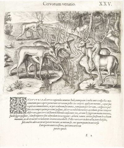
Plate XXV. Stag Hunting
The Indians have a way of hunting deer which we never saw before. They manage to put on the skins of the largest which have been taken before, in such a manner, with the heads on their own heads, so that they can see out through the eyes as through a mask. Thus accoutered, they can approach close to the deer without frightening them. They take advantage of the time when the animals come to drink at the river, and, having their bow and arrows all ready, easily shoot them, as they are very plentiful in those regions. It is usual, however, to protect the left arm with the bark of the branch of a tree, to keep it from being grazed by the bowstring-a practice which they have learned naturally enough. They know how to prepare deerskins, not with iron instruments but with shells, in a surprisingly excellent manner; indeed, I do not believe that any European could do it as well.
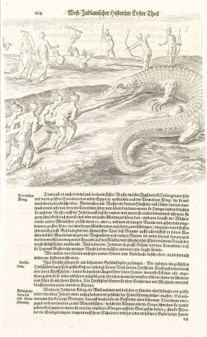
Plate XXVI. Crocodile Hunting
Their way of attacking crocodiles is as follows: They put up, near a river, a little hut full of cracks and holes, and in this they station a watchman, so that he can see the crocodiles and hear them a good way off; for, when driven by hunger, they come out of the rivers, and crawl about on the islands after prey, and if they find none, they make such a frightful noise that it can be heard for half a mile. Then the watchman calls the rest of the watch, who are in readiness; and taking a portion, ten or twelve feet long, of the stem of a tree, they go out to find the monster, which is crawling along with his mouth wide open, all ready to catch one of them if he can; and with the greatest quick ness they push the pole, small end first, as deep as possible down his throat, so that the roughness and irregularity of the bark may hold it from being got out again. Then they tum the crocodile over on his back, and with clubs and arrows pound and pierce his belly, which is softer; for his back, especially if he is an old one, is impenetrable, being protected by hard scales. This is their way of hunting crocodiles; by which they are, nevertheless, so much annoyed that they have to keep up a regular watch against them both day and night, as we should do against the most dangerous enemy.
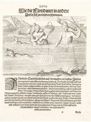
Plate XXVII. The Indians' Amusements when they Cross to the Inlands
That country abounds in most delightful islands, as the first pictures of our series show. The rivers are not deep; but the water, which comes no higher than to the breast, is very clear and pure. When they desire to make a little pleasure excursion with their wives and children to one of these islands, they cross over by swimming, in which they are very skillful; or, if they have young children, by wading. The mother can carry three children at a time, the smallest on one shoulder and holding it by one arm, the other two, holding on to her under her arms; while in her other hand she holds up a basket full of fruit or other provisions for the occasion. When there is any fear of the enemy, the men take their bows and arrows; and to keep them from being wet, they attach the quiver to the hair of the head, and hold up in one hand a bow already strung, and an arrow for instant defense, if necessary, as in the picture.
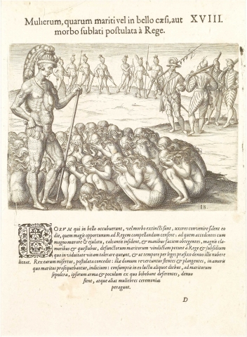
Plate XXVIII. Preparations for a Feast
At the time of year when they are in the habit of feasting each other, they employ cooks, who are chosen on purpose for the business. These, first of all, take a great round earthen vessel (which they know how to make and to burn so that water can be boiled in it as well as in our kettles), and place it over a large wood fire, which one of them drives very effectively with a fan held in his hand. The head cook now puts the things to be cooked into the great pot; others put water for washing into a hole in the ground; another brings water in a utensil that serves for a bucket; another pounds on a stone the aromatics that are to be used for seasoning; while the women
are picking over or pre paring the viands. Although they have great festivities after their manner, yet they are very temperate in eating and, in consequence, they live to a great age; for one of their inferior chiefs affirmed to me that he was three hundred years old, and that his father, whom he pointed out to me, was fifty years older; indeed, this last per-sonage, I confess, looked like nothing but the bones of a man covered with a skin. Such facts might well make us Christians ashamed, who are so immoderate in indulgence both in eating and drinking, who shorten our own lives thereby, and who richly deserve to be put under the authority of these savages and of brute beasts, to be taught sobriety.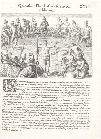
Plate XXIX. How the Floridians Deliberate on Important Affairs
The chief and his nobles are accustomed during certain days of the year to meet early every morning for this express purpose in a public place, in which a long bench is constructed, having at the middle of it a projecting part laid with nine round trunks of trees, for the chief’s seat. On this he sits by himself, for distinction’s sake; and here the rest come to salute him, one at a time, the oldest first, by lifting both hand twice to the height of the head, and saying, “Ha, he, ya, ha, ha.” To this the rest answer, “Ha, ha.” Each, as he completes his salutation, takes his seat on the bench. If any question of importance is to be discussed, the chief calls upon his Iaas (that is, his priests) and upon the elders, one at a time, to deliver their opinions. They decide upon nothing until they have held a number of councils over it, and they deliberate very sagely before deciding. Meanwhile the chief orders the women to boil some casina, which is a drink prepared from the leaves of a certain root, and which they afterwards pass through strainer. The chief and his councillors being now seated in their places, one stands before him, and spreading forth his hands wide open, asks a blessing upon the chief and the others who are to drink. Then the cupbearer brings the hot drink in a capacious shell, first to the chief, and then, as the chief directs, to the rest in their order, in the same shell. They esteem this drink so highly, that no one is allowed to drink it in council unless he has proved himself a brave warrior. Moreover, this drink has the quality of at once throwing into a sweat whoever drinks it. On this account those who cannot keep it down, but whose stomachs reject it, are not entrusted with any difficult commission or any military responsibility, being considered unfit, for they often have to go three or four days without food; but one who can drink this liquor can go for twenty-four hours afterwards without eating or drinking. In military expeditions, also, the only supplies which the hermaphrodites carry consist of gourd bottles or wooden vessels full of this drink. It strengthens and nourishes the body, and yet does not fly to the head, as we have observed on occasion of these feasts of theirs.
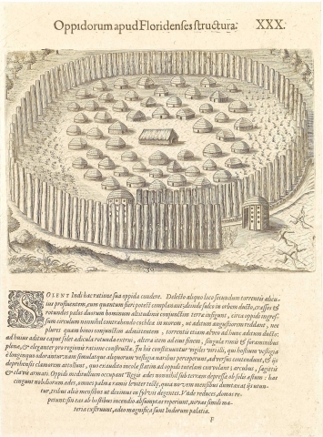
Plate XXX. How the Floridians Construct their Fortified Towns
The Indians are accustomed to build their fortified towns as follows: A position is selected near the channel of some swift stream. They level it as even as possible, and then dig a ditch in a circle around the site, in which they set thick round pales , close together, to twice the height of a man; and they carry this paling some ways past the beginning of it, spiral-wise, to make a narrow entrance admitting not more than two persons abreast. The course of the stream is also diverted to this entrance; and at each end of it they are accustomed to erect
a small round building, each full of cracks and holes, and built, considering their means, with much elegance. In these they station
as sentinels men who can smell the traces of an enemy at a great distance, and who, as soon as they perceive such traces, set off to discover them. As soon as they find them, they set up a cry which summons those within the town to the defense, armed with bows and arrows and clubs. The chief’s dwelling stands in the middle of the town, and is partly underground, in consequence of the sun’s heat. Around this are the houses of the principal men, all lightly roofed with palm branches, as they are occupied only nine months in the year, the other three, as has been related, being spent in the woods. When they come back, they occupy their houses again; and if they find that the enemy has burnt them down, they build others of similar materials. Thus magnificent are the palaces of the Indians.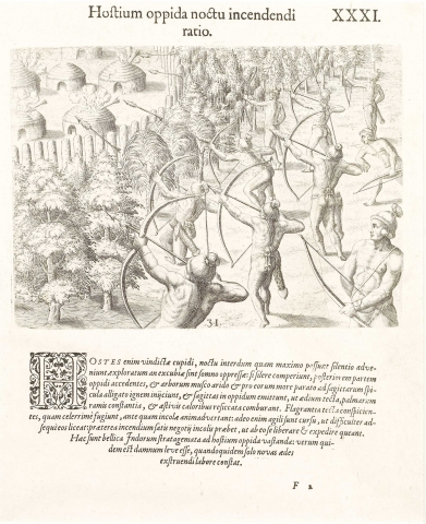
Plate XXXI. How They Destroy the Enemy's Town during the Night
For the enemy, eager for revenge, sometimes will creep up by night in the utmost silence and reconnoiter to see if the watch be asleep. If they find everything silent, they approach the rear of the town, set fire to some dry moss from trees, which they prepare in a particular manner, and fasten to the heads of their arrows. They then shoot these into the town, so as to ignite the roofs of the houses, which are made of palm branches thoroughly dried with the summer heat. As soon as they see that the roofs are burning, they make off as fast as possible before they are discovered, and they move so swiftly that it is a hard matter to overtake them; and meanwhile, also, the fire is giving the people in the town enough to do to save themselves from it and get it under. Such are the stratagems used in war by the Indians for firing the enemy’s towns; but the damage done is trifling, as it amounts only to the labor required for putting up new houses.
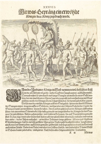
Plate XXXII. Punishments Inflicted on Negligent Sentinels
But when the burning of a town has happened in consequence of the negligence of the watch, the penalty is as follows: The chief takes his place alone on his bench, those next to him in authority being seated on another long bench curved in a half circle; and the executioner orders the culprit to kneel down before the chief. He then sets his left foot on the delinquent’s back; and taking in both hands a club of ebony or some other hard wood worked to an edge at the sides, he strikes him on the head with it so severely as almost to split the skull open. The same penalty is inflicted for some other crime reckoned capital among them; for we saw two persons punished in this same way.
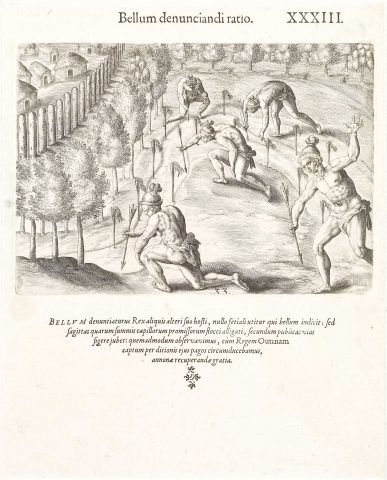
Plate XXXIII. How the Indians Declare War.
A chief who declares war against his enemy does not send a herald to do it, but orders some arrows having locks of hair fastened at the notches to be stuck up along the public ways; as we observed when, after taking the chief Outina prisoner, we carried him around to the towns under his authority, to make them furnish us provisions.
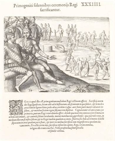
Plate XXXIV. First-Born Children Sacrificed with Solemn Ceremonies
Their custom is to offer up the first-born son to the chief. When the day for the sacrifice is announced to the chief, he proceeds to a place set apart for the purpose, where there is a bench for him, on which he takes his seat. In the middle of the area before him is a wooden stump two feet high, and as many thick, before which the mother sits on her heels, with her face covered in her hands, lamenting the loss of her child. The principal one of her female relatives or friends now offers the child to the chief in worship, after which the women who have accompanied the mother form a circle, and dance around with demonstrations of joy, but without joining hands. She who holds the child goes and dances in the middle, singing some praises of the chief. Meanwhile, six Indians, chosen for the purpose, take their stand apart in a certain place in the open area, and midway among them the sacrificing officer, who is decorated with a sort of magnificence, and holds a club. On the completion of the ceremonies, the sacrificer takes the child, and slays it in honor of the chief, before them all, upon the wooden stump. This offering was on one occasion performed in our presence.
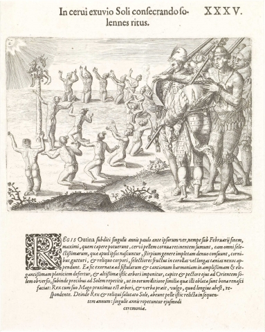
Plate XXXV. The Solemn Consecration of the Skin of a Stag to the Sun
The subjects of the chief Outina were accustomed every year, a little before their spring, that is, in the end of February, to take the skin of the largest stag they could get, keeping the horns on it; to stuff it full of all the choicest sorts of roots that grow among them, and to hang long wreaths or garlands of the best fruits on the horns, neck, and other parts of the body. Thus decorated, they carried it, with music and songs, to a very large and splendid level space, where they set it up on a very high tree, with the head and breast toward the sunrise. They then offered prayers to the sun that he would cause to grow on their lands good things such as those offered him. The chief, with his sorcerer, stands nearest the tree, and offers the prayer; the common people, placed at a distance, make responses. Then the chief and all the rest, saluting the sun, depart, leaving the deer hide there until the next year. This ceremony they repeat annually.
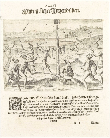
Plate XXXVI. The Exercises of the Youth
Their youth are trained in running, and a prize is offered for him who can run longest without stopping; and they frequently practice with the bow. They also play a game of ball, as follows: in the middle of an open space is set up a tree some eight or nine fathoms high, with a square frame woven of twigs on the top; this is to be hit with the ball, and he who strikes it first gets a prize. They are also fond of amusing themselves with hunting and fishing.
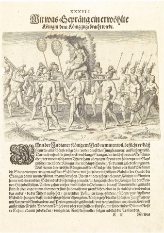
Plate XXXVII. The Pomp with Which the Queen-Elect is Brought to the King
When a king chooses to take a wife, he directs the tallest and handsomest of the daughters of the chief men to be selected. Then a seat is made on two stout poles, and covered with the skin of some rare sort of animal while it is set off with a structure of boughs, bending over forward so as to shade the head of the sitter. The queen elect having been placed on this, four strong men take up the poles, and support them on their shoulders, each carrying in one hand a forked wooden stick to support the pole at halting. Two more walk at the sides, each carrying on a staff a round screen elegantly made, to protect the queen from the sun’s rays. Others go before, blowing upon trumpets made of bark, which are smaller above, and larger at the farther end, and having only the two orifices, one at each end. They are hung with small oval balls of gold, silver, and copper, for the sake of a finer combination of sounds. Behind follow the most beautiful girls that can be found, elegantly decorated with necklaces and armlets of pearls, each carrying in her hand a basket full of choice fruits, and belted below the navel, and down to the thighs, with the moss of certain trees, to cover their nakedness. After them come the body guards.
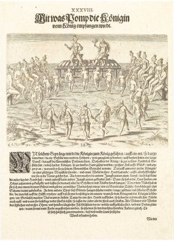
Plate XXXVIII. The Solemn Reception of the Queen by the King
With this display the queen is brought to the king in a place arranged for the purpose, where a good-sized platform is built up of round logs, having on either side a long bench where the chief men are seated. The king sits on the platform on the right-hand side. The queen, who is placed on the left, is congratulated by him on her accession, and told why he chose her for his first wife. She, with a certain modest majesty, and holding her fan in her hand, answers with as good a grace as she can. Then the young women form a circle without joining hands, and with a costume differing from the usual one; for their hair is tied at the back of the neck, and then left to flow over the shoulders and back; and they wear a broad girdle below the navel, having in front something like a purse, which hangs down so as to cover their nudity. To the rest of this girdle are hung ovals of gold and silver, coming down upon the thighs, so as to tinkle when they dance, while at the same time they chant the praises of the king and queen. In this dance they all raise and lower their hands together. All the men and women have the ends of their ears pierced, and pass through them small oblong fish bladders, which when inflated shine like pearls, and which, being dyed red, look like a light-colored carbuncle. It is wonderful that men so savage should be capable of such tasteful inventions.
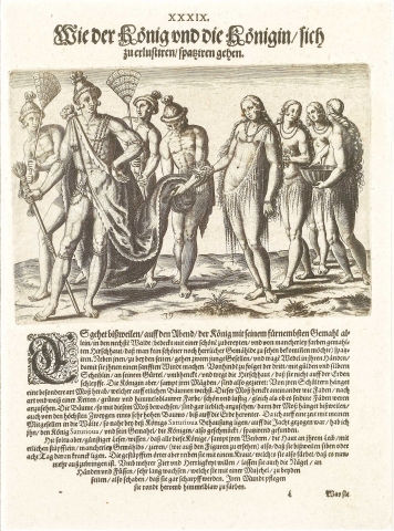
Plate XXXIX. The Recreational Walks of the King and Queen
Sometimes the king likes to take a walk in the evening in a neighboring wood, alone with his principal wife, wearing a deer hide so elegantly prepared, and painted of various colors, that nothing more beautifully finished can be seen anywhere. Two young men walk at his sides carrying fans to make a breeze for him; while a third, ornamented with little gold and silver balls hanging to his belt, goes behind, and holds up the deer hide, so that it shall not drag on the ground. The queen and her handmaids are adorned with belts hung on the shoulders or around the body, made of a kind of moss that grows on some trees; with slender filaments which are attached to each other, after the fashion of links of a chain, of a bluish-green color, and so beautiful in texture that it might be mistaken for fila-ments of silk. The trees laden with this moss are beautiful to see; for it sometimes hangs down from the highest boughs of a very tall tree to the ground. While hunting once with some of my fellow soldiers in the woods near King Saturiova’s residence, I saw him and his queen thus decorated.
The reader should be informed that all these chiefs and their wives ornament their skin with punctures arranged so as to make certain designs, as the following pictures show. Doing this sometimes makes them sick for seven or eight days. They rub the punctured places with a certain herb, which leaves an indelible color. For the sake of further ornament and magnificence, they let the nails of their fingers and toes grow, scraping them down at the sides with a certain shell, so that they are left very sharp. They are also in the habit of painting the skin around their mouths of a blue color.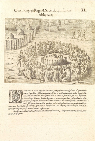
Plate XL. Funeral Ceremonies in Honour of the Kings and Priests
When a chief in that province dies, he is buried with great solemnities; his drinking cup is placed on the grave, and many arrows are planted in the earth about the mound itself. His subjects mourn for him three whole days and nights, without taking any food. All the other chiefs, his friends, mourn in like manner; and both men and women, in testimony of their love for him, cut off more than half their hair.
Besides this, for six months afterwards certain chosen women three times every day, at dawn, noon, and twilight, mourn for the deceased king with a great howling. And all his household stuff is put into his house, which is set on fire, and the whole burned up together.
In like manner, when their priests die, they are buried in their own houses; which are then set on fire, and burned up with all their furniture.
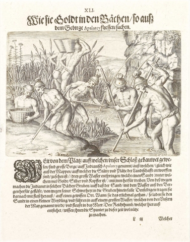
Plate XLI. How Gold is Collected in the Rivers Running from the Appalachian Mountains
A great way from the place where our fort was built, are great mountains, called in the Indian language Apalatcy; in which, as the map shows, arise three great rivers, in the sands of which are found much gold, silver, and copper, mixed together. Accordingly, the natives dig ditches in these streams, into which the sand brought down by the current falls by gravity. Then they collect it out, and carry it away to a place by itself, and after a time col-lect again what continues to fall in. They then convey it in canoes down the great river which we named the River of May, and which empties into the sea. The Spaniards have been able to use for their advantage the wealth thus obtained.
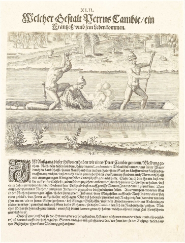
Plate XLII. The Murder of the Frenchman, Pierre Gambie
I have spoken in my Brief Account of one Pierre Gambie a Frenchman, who obtained a license from Laudonniere for carrying goods and trading throughout the province; and who was successful enough not only to accumulate considerable means, but also to marry into the family of a certain chief of the country. Being seized with an earnest desire of returning to see his friends at the fort, he urged his new relative until he got permission to go, but on condition of returning within a fixed number of months; and a canoe was provided for him besides, and two Indians to convey him. The goods which he had obtained were stowed in the boat; and his Indian companions murdered him while on the journey, while he was stooping over to make a fire. This was done partly in revenge, as he had, while acting in the chief’s absence in his stead, beaten one of them with his fists; and partly out of greediness for the riches which the soldier had within the boat. These they took, and fled; and the facts were unknown for a long time.
This picture, not to interrupt the series of those preceding it, is put last; nor would it have been inserted at all, had not the author of the Brief Account remembered the circumstances.
